This week's lab focused all on assessing the vertical accuracy of DEMs. For the lab this week I analyzed the vertical accuracy of a DEM of river tributaries within North Carolina. To assess the DEM's vertical accuracy, I was given reference point data taken by high accuracy surveying equipment. The 287 reference points were taken at five various landcover type locations. These land cover types are as follows:
- A - Bare Earth/Low Grass
- B - High Grass/Weeds/Crops
- C - Brushland/Low Trees
- D - Fully Forested
- E - Urban
To assess the vertical accuracy of the DEM I extracted the elevation values from each cell that where each reference survey point fell. Now that I had the actual elevation points and a set of reference points for each actual value, I could compare the results. To assess accuracy, I calculated 4 statistical numbers for each land cover type and the dataset as a whole. My four statistical numbers included accuracy at the 68th percent confidence interval, the accuracy at the 95th percent confidence interval, the RMSE (Root Mean Square Error), and the Bias (Mean Error). The Root Mean Square Error is the most used metric to assess and calculate accuracy. Higher RMSE values mean lower accuracy and lower RMSE values mean higher accuracy. My results can be seen below.
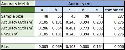
For my analysis, the Bare Earth has the highest accuracy with the fully forested land cover having the lowest. This is no surprise as creating a digital elevation model of the varying land cover of the earth's surface can be quite challenging since various land cover types can vary in terms of accuracy.
~Map On!
No comments:
Post a Comment